Nonaville, between Lebanon Road and Old Hickory Lake, is zoned for Green Hill High. ZIP 37122 was $565,761 in September 2026, per Zillow.
Last checked Oct. 17, 2026. Sources: the City of Mt. Juliet’s Land Use and Transportation Plan Update (PDF), the 2016 plan on the city’s Planning and Zoning page; Wilson County Schools’ school zone lookup; the Tennessee Department of Education’s 2024-25 A-F letter grade file; the federal NCES school directory; the Zillow Home Value Index (Zillow Research); and OpenStreetMap (© OpenStreetMap contributors).
Nonaville is the northwest corner of Mount Juliet, the land between Lebanon Road and Old Hickory Lake. The city’s land use plan names it Planning Area 1, Nonaville, about 4,050 acres stretching from Cedar Creek west to the edge of the city’s urban growth boundary. It holds the city’s lake frontage on this side, with a public campground and a marina on Saundersville Road, and Green Hill High School on North Greenhill Road.
What this means for you
- Zoned high school: Green Hill High, 220 N. Greenhill Road (2024-25 state letter grade: A).
- Home value: $565,761 in ZIP code 37122 in September 2026, according to the Zillow Home Value Index.
- Nearest I-40 exit: Exit 226, Mt. Juliet Road (State Route 171).
Part of our Mount Juliet neighborhoods guide.
Where it is
The plan draws Nonaville’s boundaries as Old Hickory Lake to the north, Cedar Creek to the east, Lebanon Road (U.S. 70) to the south and the city’s urban growth boundary to the west. Nonaville Road and Saundersville Road are the main roads through it, and North Greenhill Road runs up from Lebanon Road past the high school. Not all of the planning area is inside the city limits; the plan covers the city and the land it expects to grow into. The Census Bureau’s ZIP code areas put the city in 37122.
The plan lists these landmarks in the area:
- Cedar Creek Campground, 9264 Saundersville Road, with 59 campsites, a boat ramp, a playground, picnic shelters and swimming
- Cedar Creek Marina on Old Hickory Lake, 9120 Saundersville Road, with a launch ramp, gas docks and a restaurant
- Windtree Golf Course, 810 Nonaville Road
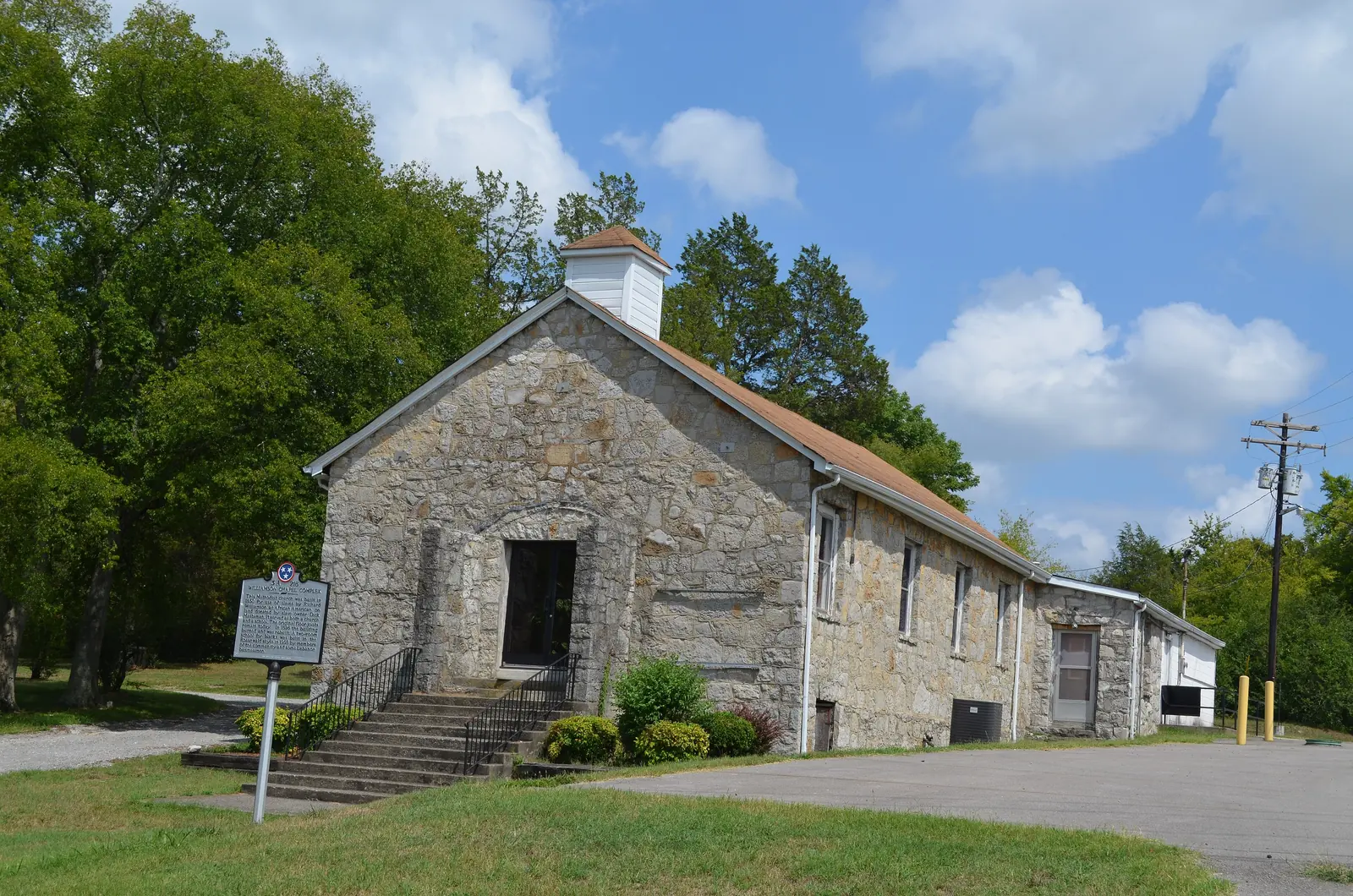
- The Williamson Chapel CME Church Complex on Needmore Road, pictured above
- Cloydland Farms, a Tennessee Pioneer Century Farm on Lebanon Road established in 1789, and Rice’s Country Hams at the corner of Nonaville and Lebanon roads
The plan’s to-do list for the area is short: sidewalks along Nonaville and Lebanon roads, greenways and bike routes, and design standards for building on steep ground and floodplains.
Schools
We checked 11 points spread across the part of Nonaville inside the city limits in the district’s zone lookup, and every one returned the same three schools. Grades are from the Tennessee Department of Education’s 2024-25 A-F letter grades.
| Level | School | Address | 2024-25 grade |
|---|---|---|---|
| Elementary | W.A. Wright Elementary | 5017 Market Place | A |
| Middle | Mt. Juliet Middle | 3565 N. Mt. Juliet Road | A |
| High | Green Hill High | 220 N. Greenhill Road | A |
W.A. Wright Elementary is the one school the 2016 plan lists in Nonaville. Green Hill High’s campus is north of Lebanon Road, inside the area’s boundaries, though the plan does not list it. Lakeview Elementary, 6211 Saundersville Road, is just outside the area to the west. Look up one address in the zone lookup and see each school’s full results on the Tennessee State Report Card. More in our schools guide.
Home values
Zillow’s typical home value for ZIP code 37122 was $565,761 in September 2026, up 0.5% from $562,819 a year earlier. For the city as a whole it was $556,817. The Zillow Home Value Index is a modeled value for a typical mid-priced home, not a sale price, and Zillow does not publish it for areas smaller than a ZIP code. More in home prices.
Parks and the lake
- Cedar Creek Campground and Cedar Creek Marina on Saundersville Road, listed above, are the area’s public way onto Old Hickory Lake.
- Charlie Daniels Park, 1075 Charlie Daniels Parkway, the city’s main park, is just across Cedar Creek in the Cedar Creek area.
The plan calls for dedicated greenways and bike routes here; none is listed as built. More in parks and trails.
Getting around
- Main roads: Lebanon Road (U.S. 70) along the south edge, Nonaville Road and Saundersville Road through the area.
- Nearest I-40 exit: Exit 226 (Mt. Juliet Road, State Route 171), reached down North Mt. Juliet Road. The western edge is closer to Exit 221 (State Route 45, Old Hickory Boulevard) in Hermitage. Exit numbers are from OpenStreetMap.
- Distances by road from W.A. Wright Elementary, measured on OpenStreetMap’s road network: about 3.8 miles to City Hall, 2425 N. Mt. Juliet Road, and about 13.6 miles to Nashville International Airport. These are distances, not drive times.
- Transit: the nearest is the WeGo Star commuter train at Mt. Juliet Station, 22 E. Division St.
More in getting around.
Groceries and everyday stores
OpenStreetMap shows the nearest stores at the corner of Lebanon Road and North Mt. Juliet Road, at the southeast edge of the area:
- Publix, 11207 Lebanon Road
- Walgreens, 11185 Lebanon Road
- Kroger, 4120 N. Mt. Juliet Road
Related: Cedar Creek, Greenhill, property taxes and moving to Mount Juliet.
Frequently asked questions
Where is Nonaville in Mount Juliet?
Nonaville is the city’s name for Planning Area 1: the land north of Lebanon Road and west of Cedar Creek, running up to Old Hickory Lake, about 4,050 acres in the city’s land use plan.
What schools is Nonaville zoned for?
W.A. Wright Elementary, Mt. Juliet Middle and Green Hill High, at all 11 points we checked inside the city limits in the Wilson County Schools zone lookup. All three earned an A on Tennessee’s 2024-25 letter grades.
Is Nonaville a good place to live?
Here are the facts. Nonaville is a 4,050-acre planning area on Old Hickory Lake with Cedar Creek Campground and Cedar Creek Marina, zoned for Green Hill High, which earned an A for 2024-25; the typical home value in ZIP 37122 was $565,761 in September 2026, according to Zillow.
How far is Nonaville from the Nashville airport?
About 13.6 miles by road from W.A. Wright Elementary to Nashville International Airport, measured on OpenStreetMap’s road network. That is a distance, not a drive time.
Have your say